
Take a look at this map and you will see there are some parcels in our neighborhood that will change under the new flood maps. The changes seem to be very limited in our neighborhood and all of the changes are saying the chances of flooding are less under this new map study than under the old one.
Don’t take our word for it. See for yourself. You can view the map changes at www.pinellascounty.org/flooding/fema_firm.htm
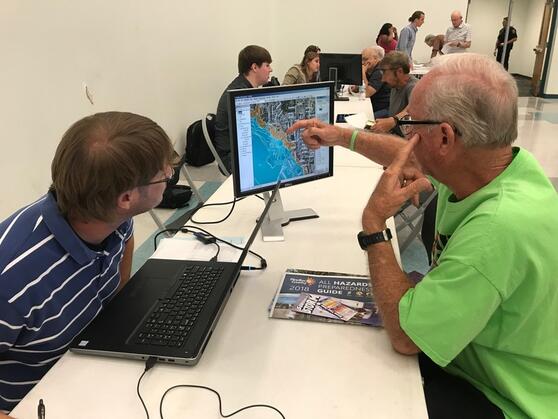
As you will see, the map is a “slider” that shows before and after the changes. Just enter your address and the map will zoom in on you.
Public meetings set ahead of FEMA-proposed flood insurance rate map adoption
• Three open house-style meetings will be held in June
• Meetings are to inform residents about map changes that may affect their flood risk, flood insurance requirements and rates moving forward
• County property owners have until July 31 to contest proposed changes in Pinellas County’s Flood Insurance Rate Maps (FIRMs) with updated scientific and technical data.
Preferred-risk flood insurance policies should be purchased before the Federal Emergency Management Agency (FEMA) issues Letters of Final Determination and the updated FIRM becomes effective.
To help explain the changes and what actions property owners may need to take, Pinellas County is holding three open house-style meetings in June.
- The first two meetings will be held on Tuesday, June 11, at the Lealman Exchange, located at 5175 45th St. N., in St. Petersburg.
- An afternoon meeting is scheduled from 2 until 4 p.m., and an evening meeting will be held from 6 until 8 p.m.
- The third meeting will be held on Tuesday, June 25, in the Oldsmar City Council Chambers, located at 101 State St. W., in Oldsmar. The meeting will take place from 11 a.m. until 2 p.m.
The meetings will provide valuable information to property owners that may be affected by proposed changes to Pinellas County’s FIRM. Home and business owners, renters, real estate agents, mortgage lenders, surveyors and insurance agents are encouraged to attend. The same information will be provided at all three meetings. There will be no formal presentation. The community meetings will be held in an open house format to allow citizens to talk to insurance specialists and technical specialists about the preliminary maps. Representatives from Pinellas County, several cities and the Southwest Florida Water Management District (SWFWMD) will also be in attendance.
Property owners can view their current flood zone and potential map change at www.pinellascounty.org/flooding/fema_firm.htm.
Although it is not required, property owners are advised to bring their elevation certificates if they have one.
In some cases, the certificates may be downloaded from www.pinellascounty.org/flooding/elevation.htm for properties in the unincorporated county or obtained from the cities in which the property is located.
For more information about flooding in Pinellas County and flood insurance, visit www.pinellascounty.org/flooding.
Resources
Map Changes and Flood Insurance: What Property Owners Need to Know ![]()
Coastal Flood Risk Analysis and Mapping Process ![]()
Coastal Flood Risk Information and the Limit of Moderate Wave Action ![]()
Criteria for Appeals of Flood Insurance Rate Maps ![]()
Flood Map Changes: Tips and Talking Points for Insurance Professionals ![]()
Information for Homeowners, Renters, Business Owners, and General Public ![]()
Information for West Florida Study Area ![]()
Overview of Flood Hazard Mapping Updates ![]()
Understanding Preliminary Flood Hazard Maps ![]()
Using the Limit of Moderate Wave Action (LiMWA) to Build Safer and Stronger Coastal Communities ![]()
View Your Community’s Preliminary Flood Hazard Data ![]()